Curated News
By: NewsRamp Editorial Staff
June 17, 2026
Western Star Unveils UAV Magnetic Survey Results at Rowland Tungsten Property
TLDR
- Western Star's UAV survey reveals untested magnetic domains, potentially extending tungsten mineralization and offering a first-mover advantage.
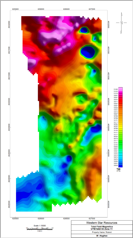
- High-resolution UAV magnetic survey identifies structural lineaments and skarn horizons, guiding Phase 2 drill targeting with processed TMI, 1VD, 2VD, and AS data.
- Western Star aims to revitalize North America's tungsten supply, reducing reliance on foreign sources for this critical mineral in technology and defense.
- First modern UAV magnetic survey at Rowland reveals hidden fault structures and possible extensions of tungsten skarn horizons south of historical zones.
Impact - Why it Matters
This news matters because it provides critical insights into the structural controls of tungsten mineralization at the Rowland property, a past-producing site in Nevada. Tungsten is a critical mineral for defense and technology, and the U.S. relies heavily on imports. By identifying untested magnetic anomalies and refining drill targets, Western Star is advancing the potential for a domestic tungsten source, which could reduce supply chain vulnerabilities. For investors, these results de-risk exploration efforts and pave the way for a maiden drilling campaign, offering a clearer path to resource definition. The integration of modern geophysics with geochemistry enhances the probability of discovery, making this a key milestone for the company and for North American tungsten supply.
Summary
Western Star Resources Inc. (CSE: WSR) (OTC: WSRIF) (FRA: 4K2) has announced results from a high-resolution UAV magnetic geophysical survey at its Rowland Tungsten Property in Elko County, Nevada. The survey, the first modern geophysical dataset acquired at the property, aimed to improve understanding of structural controls on mineralization and refine geological interpretations. Key processed products include Total Magnetic Intensity (TMI), First Vertical Derivative (1VD), Second Vertical Derivative (2VD), and Analytical Signal (AS). Results indicate that several existing target zones correspond to northeast-southwest trending magnetic lineaments, interpreted as potential fault structures and fluid pathways. Historical workings and Phase 1 target areas appear spatially associated with refined contacts between intrusive and carbonate rocks, suggesting prospective skarn horizons. Notably, a magnetic-high domain and adjacent magnetic-low domain immediately south of the historical Rowland zone represent untested features that may indicate extensions of the skarn horizon. These results will be integrated with pending Phase 1 soil geochemistry to design a Phase 2 exploration program and refine potential drill targets.
CEO and President Blake Morgan emphasized the importance of this survey, stating it represents a critical step in building the first modern exploration dataset at Rowland. The survey has highlighted multiple structural features and magnetic domains linked to historical workings and interpreted skarn horizons. The company looks forward to integrating these results with Phase 1 soil geochemistry, expected imminently, as it advances toward Phase 2 exploration and defining priority targets for a maiden drilling campaign. The Rowland area previously had limited high-resolution geophysical coverage, and this drone survey provides a cost-effective dataset that significantly improves interpretation of the structural and geological setting. Preliminary interpretation identified multiple northeast-southwest trending linear features across the property, interpreted as possible fault or fracture zones that may have channeled hydrothermal fluids for tungsten-bearing skarn mineralization. Historical activity areas coincide with interpreted intrusive-carbonate contacts and magnetic lineaments, which is encouraging for tungsten skarn systems that develop where mineralizing fluids interact with reactive carbonate rocks near intrusions. The survey also suggests the mapped intrusive system may be more extensive than previously recognized, potentially extending the prospective contact zone beyond historically worked areas.
The magnetic-high and adjacent magnetic-low domains south of the historical Rowland zone are untested geophysical features that will be evaluated in Phase 2 exploration, possibly indicating extensions of the Rowland Main zone or additional prospective skarn horizons. Western Star Resources is an emerging junior mineral exploration company focused on revitalizing North America's tungsten supply, advancing its entry into the U.S. market through acquisition of a past-producing tungsten mine in Nevada. The company also owns mineral claims in British Columbia. The scientific and technical information has been reviewed by Qualified Person Jasper Mowatt. For more details and figures, readers can click the hyperlinks in the release: Click Here to see Figure 2: Total Magnetic Intensity (TMI) image of the property and others for derivative images. The integration of geophysics with pending assay results will define priority drill targets and inform the Phase 2 exploration program at Rowland.
Source Statement
This curated news summary relied on content disributed by NewMediaWire. Read the original source here, Western Star Unveils UAV Magnetic Survey Results at Rowland Tungsten Property